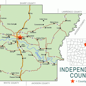
 Independence County Map
 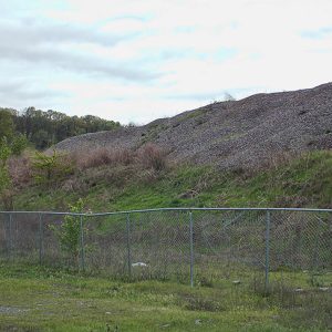 Rock Point (a.k.a. Rocky Point)
501-918-3025
calsfoundation@cals.org
calsfoundation@cals.org
Rocky Point, originally called Rock Point, is located on Highway 167 (Batesville Boulevard), about seven miles south of Batesville (Independence County), the county seat. Once a thriving community, twenty-first-century Rocky Point consists of a rock quarry called Rocky Point Materials. Rocky Point represents the dividing line between the Southside School District and the Midland School District of Pleasant Plains (Independence County).
Rock Point is the rock formation at the southern point of where the Caney Creek bottoms end. In the early days of settlement, the bottomland provided suitable soil for small-scale farming, and the hill area was good for hunting small game, deer, and bears. Ample pasture land allowed for the running of cattle.
Initially a part of the Round Pond community, Rock Point was officially placed on the map on February 17, 1842, when a post office was opened. William Seamans, who was born in Tennessee around 1811, was appointed postmaster. Seamans had resided at Rock Point since August 16, 1838. He had staked a claim in Batesville, and he supplemented it with more land in 1842 and 1844.
The Rock Point post office was part of a trading post. There was also a blacksmith shop run by James H. Brundrett, who was born in Cheshire, England, in Missouri on the 1820 census, and was living on Caney Creek with his family by 1834. Brundrett had started as a blacksmith in a shop run by his brother-in-law, Peter Linebarger, at the nearby Caney community. James and Peter were members of the County Home Guard of Minute Men for the Confederacy in 1861.
The Tucker family of White Run, where Salado Creek empties into White River, became one of the most prominent families to settle in Rock Point in the pre–Civil War days. Children of Peyton Tucker, first postmaster in Independence County (at White Run circa 1814), and his wife, Sarah Capshaw Tucker, settled at Rock Point. Their son, Henry Capshaw Tucker, was a leading member of the County Home Guard of Minute Men for the Confederacy in 1861. A grandson, William Peyton Tucker, married Parilee Rushing, part of another leading family of the area. Her father, Enoch Deason Rushing of Rock Point, represented Independence County in the Union-aligned Arkansas General Assembly, serving in the Arkansas Senate from April 11, 1864, until April 22, 1865, during the final days of the Confederacy. He again served in the Arkansas Senate from 1868 to 1872.
The Brundrett and Linebarger families had family ties by at least three marriages, as James Brundrett and two of his sisters married Linebarger siblings. James Brundrett and Peter Linebarger both died during the Civil War (cause of death unknown), leaving their families in Rock Point and Caney unprotected. Family lore relates that Mary Ann Linebarger, Peter’s widow, and her daughter were robbed by jayhawkers of horses and money which they had put into the apron pocket worn by a grown daughter, Leticia Linebarger. The women then put on men’s clothes, including overalls, and rode out after the thieves and got their horses and money back by sneaking up on them. Peter had a picket fence around his grave at Kyler Cemetery which was also torn up during the fracas.
During the Civil War, Rock Point had been at the center of Rebel resistance in the hill areas south of the White River. The Rock Point community began its decline during Reconstruction. The post office closed in 1878, and the original settlers began drifting away to Salado (Independence County), Pleasant Plains, and elsewhere.
One of Peter Linebarger’s grandsons was involved in a shootout at the silent-movie house in Pleasant Plains on May 23, 1926. Charlie and Bob Linebarger had been charged with moon shining a few weeks before and were apprehended by a neighbor, Deputy Sheriff George Moore. The incident escalated and exploded into violence at Bert’s Little Picture Show, where both Charlie Linebarger and George Moore were killed.
When the old road from Batesville to Pleasant Plains was replaced in 1926 with Highway 11 South, (which became Highway 167 in 1962), a sharp curve was created around Rock Point; this became known locally as Deadman’s Curve, as several deadly wrecks occurred there over the years. When the highway was widened between Bald Knob (White County) and Batesville in 2002, the curve became easier to navigate.
Mining began in the area in the twentieth century. Rocky Point Materials, which has a Batesville address, employs about ten people and specializes in mining rock for residential and commercial purposes. The company’s mining activities have erased any evidence of a once-thriving community of farmers and woodsmen. Though a few families still live in the Caney Creek bottoms, and Packs Discount lumber store is located near Caney Creek, no one lives at the old Rock Point settlement.
For additional information:
Tucker, R. W. “Peyton Tucker, Pioneer.” Independence County Chronicle 13 (July 1972): 16–23.
Kenneth Rorie
Van Buren, Arkansas


Comments
No comments on this entry yet.