 Environment
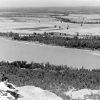 Geography and Geology
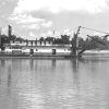 Rivers
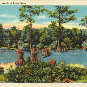 Fourche Creek
 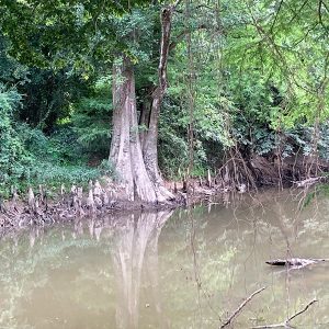 Fourche Creek
 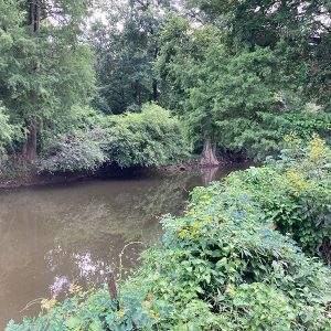 Fourche Creek
 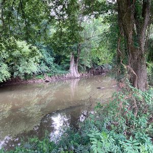 Fourche Creek
501-918-3025
calsfoundation@cals.org
calsfoundation@cals.org
Fourche Creek is a winding stream that flows more than twenty-four miles through southern Little Rock (Pulaski County). It is within the city limits for most of its length, from its headwaters south of Lawson Road at an elevation of 354 feet above mean sea level (AMSL) to its convergence with the Arkansas River near Interstate 440 (227 feet AMSL). Due to the density of the population around Fourche Creek, almost 200,000 Arkansans live within its watershed, more people than reside in the watershed of any other stream that both begins and ends in Arkansas.
Fourche Creek was named by French explorers who became associated with the Quapaw who inhabited the bottomlands around Fourche Creek in the mid-seventeenth century. The Quapaw trapped fish using weirs along the creek. “Fourche” is French for “fork,” as in “fork in the road,” and locals today pronounce its name by omitting the “r” and rhyming it with “bush.” Fourche Creek should not be confused with the Fourche River, which arises in Missouri and empties into the Black River in Randolph County, or the Fourche La Fave River, which arises in the Ouachita Mountains and flows through Yell and Perry counties to empty into the Arkansas River.
Six streams are tributaries to Fourche Creek: Fourche Bayou, Rock Creek, Otter Creek, Brodie Creek, Crooked Creek, and Panther Creek; there are also several smaller branches. Fourche Creek is bridged by three interstate highways, two railroads, seven major thoroughfares, and numerous utility lines and pipes. Removal of green spaces that slow runoff—combined with the development of roads, buildings, and parking lots within its watershed—has caused the Fourche and its tributaries to be subject to frequent flash flooding. The U.S. Geological Service (USGS) maintains a station where the creek runs beneath University Avenue. The USGS regularly monitors water level, rate of flow, water temperature, water quality, and other variables for Fourche Creek.
Fourche Creek’s 112-square-mile watershed drains and filters runoff from seventy-three percent of Little Rock. The storm drain system for the city picks up a massive amount of chemical pollutants, bottles, Styrofoam cups, floatable toys, and other such trash and washes it into the Fourche. As a result, the creek has become an eyesore. In addition, much of the septic sewer system of the city of Little Rock follows a path parallel to Fourche Creek. If there is a break or malfunction in the system, raw sewage empties into its waters.
Frequent flooding prevents construction of buildings on property closely adjacent to the creek, and that land, known as the “Fourche Bottoms,” hosts a forest of cypress, tupelo, and hardwoods. The bottoms are suitable for other types of development, however. Ten municipal parks, most with ballfields, are adjacent to the creek and its tributaries. In spite of the great amount of trash in the bottoms, there is abundant wildlife, including birds. Many types of fish swim in its water, including catfish, bass, crappie, bluegill carp, and drum. Other species of aquatic fauna that were once plentiful in Fourche Creek—including amphiuma, sturgeon, and alligator gar—are now rarely found there.
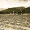
In the early 1830s, one of the routes of the Trail of Tears took Choctaw and Chickasaw across Fourche Creek on Stagecoach Road. In September 1863, the Confederates lost a pivotal battle fought along Fourche Creek near what is now Lindsey Road, allowing Union forces to occupy Little Rock. By the 1920s, a string of dairies and hog farms had begun operation along its banks. Accompanying slaughterhouses dumped the wastes from butchering directly into the waters of the creek. A postcard dated circa 1935 indicates that there was logging of the cypress along the creek.
In 1943, two third-grade boys attempting to use a wooden cement-making box as a boat drowned in Fourche Creek when the box sank near what is now Interstate Park. Dead bodies are also occasioally found in the creek, often murder victims.
In 2010, a consortium of canoeists, environmentalists, civic volunteers, and governmental leaders who called themselves “Friends of Fourche Creek” began a movement to clean the Fourche by removing decades of castoff refuse, securing grants to restore habitat for wildlife, and promoting the creek’s economic potential. The group envisions rendering it suitable for outdoor activities and recreation such as floating, fishing, birdwatching, and eco-tourism.
For additional information:
Butler, Jerry. “Floating the Fourche.” Arkansas Times, August 6, 2015, pp. 14–17. Online at http://www.arktimes.com/arkansas/floating-the-fourche/Content?oid=3999669 (accessed October 22, 2020).
Fourche Creek Watershed Initiative. Audubon Arkansas. http://fourchecreek.org/ (accessed October 22, 2020).
Kelley, Michael Brent. “Survey of Fish and lampsilis Species A and Mash Bird Habitat Improvement in Fourche Creek Watershed.” State Wildlife Grant No. T3208 Final Report, 2012.
Scheiman, Dan. “The Fourche Creek Watershed.” Pulaski County Historical Review 67 (Winter 2019): 131–133.
Smith, Zachary. “Quantifying the Impact of Urbanization on the Fourche Creek Watershed, Little Rock, Arkansas.” MS thesis, University of Arkansas at Little Rock, 2021.
United States Geological Survey. USGS 07263555 Fourche Creek at University Avenue in Little Rock, Arkansas. http://waterdata.usgs.gov/usa/nwis/uv?07263555 (accessed October 22, 2020).
Jerry Butler
University of Arkansas at Little Rock


Comments
No comments on this entry yet.