 Early Twentieth Century, 1901 through 1940
 Historic Preservation
 Marked Tree Siphons
 Science and Technology
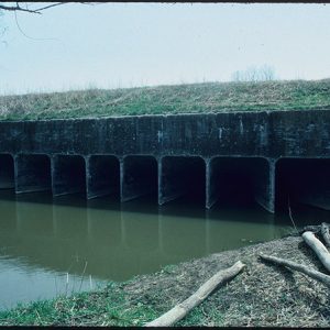 Rivervale Inverted Siphons
501-918-3025
calsfoundation@cals.org
calsfoundation@cals.org
Completed in 1926, the Rivervale Inverted Siphons were a prerequisite to permanent settlement in eastern Poinsett County and adjacent areas in the St. Francis River and Little River basins. The siphons provided relief from overflow and outlet for runoff from Craighead and Mississippi counties and portions of southeastern Missouri. One of the first components in the comprehensive drainage plan devised for Drainage District Number Seven of Poinsett County, the Rivervale Inverted Siphons also permitted the immediate agricultural development and economic exploitation of parts of Poinsett County and those counties in Missouri and Arkansas tributary to District Seven. They were also a necessary response to the proliferation of organized drainage and levee districts in the early twentieth century. The siphons were listed on the National Register of Historic Places on March 22, 1991.
From 1910 to 1920, the number of drainage districts organized in Arkansas, Mississippi, and Missouri reached a peak. In 1917, the Mingo Drainage District and the Inter-River Improvement District were created in Missouri and provided the final provocation for the inhabitants of eastern Arkansas. The Marked Tree Gazette editorialized at length on “this threatened destruction.” According to engineers, the planned improvements would increase the flow of the St. Francis River in Arkansas in times of flood five to ten times its previous volume. If the plans were completed, the Gazette predicted “nothing short of ruination for the people of the St. Francis river valley,…drowning us out of homes and away from our farms and factories. There is nothing more serious threatening us than these two Missouri districts.”
Incited by the formation of the new districts, Senator Thaddeus H. Caraway joined the Marked Tree (Poinsett County) newspaper in its assessment of the future. In a letter to the “prominent men in Eastern Arkansas,” the senator warned that Missouri intended to divert the overflow from the Ozark Mountains and “turn the entire column loose on Arkansas.” Caraway counseled Arkansans to seek an injunction against the Missouri improvement districts until the United States government canalized or dredged the St. Francis River to control the increased volume of water. A solemn editorialist for the Marked Tree Tribune agreed and warned that, if the Missouri projects were completed, “the entire St. Francis basin [would] become a wilderness of water.”
With the proliferation of local efforts, Congress finally responded to the increasingly apparent need for a consistent flood-control policy. The Ransdell-Humphreys Flood Control Act of 1917 reaffirmed the federal government’s commitment to flood prevention and control, although the $45 million appropriation was insufficient. Local interests were encouraged by a provision of the act that reduced their contribution to one-half the cost of flood prevention works in their area, down from the two-thirds previously required.
In the same year, with the renewed interest in flood prevention, the Arkansas General Assembly authorized the establishment of six drainage districts by direct legislation. Act 193 created Drainage District Number Seven in Poinsett County. The district boundaries, which originally encompassed the lands between Crowley’s Ridge and the St. Francis River and Lake, were amended in 1919 to include a total of 190,000 acres in eastern Poinsett County. In 1919, the district, one of the largest in the country, began a series of ambitious, interrelated projects designed to reclaim “the lands therein by drainage ditches and levees.”
The first concern of the new district’s directors was management of waters that entered Poinsett County from adjacent counties. The natural outlet for Drainage District Number Seventeen of Mississippi County was through the Right Hand and Left Hand Chutes of the Little River, which joined the St. Francis River north of Marked Tree, within the boundaries of Drainage District Number Seven. A number of other watersheds were tributary to District Seven, as well. Parts of the drainage of Districts Sixteen and Seventeen of Mississippi County, Districts Nine and Eighteen of Craighead County, and part of the runoff from Dunklin County, Missouri, originally had their outlet through Buffalo Creek, which emptied into the Right Hand Chute in District Seven. As part of their improvements, the Arkansas and Missouri drainage districts straightened and deepened the shallow, sluggish creek to handle increased flow. The improved channel, renamed Ditch Number Four, increased the drainage burden imposed on the northeastern portion of District Number Seven.
As part of their comprehensive drainage plans, Districts Seventeen and Seven proposed to construct floodways to contain the Right Hand Chute of the Little River and the St. Francis River. With the completion of leveed basins and channels for the two waterways, a manmade basin or bowl would be created in the northeastern corner of Poinsett County, and drainage would be restricted to a single outlet into the Right Hand Chute of the Little River. Because of the shallow slopes, which averaged one foot per mile, and the limited channel capacity of the Right Hand Chute, District Number Seven Engineers—the Pride and Fairley firm of Blytheville—anticipated disastrous overflows in that portion of the district and in adjacent districts. To contend with the heavy runoff from already organized districts, the Blytheville (Mississippi County) engineering firm devised and evaluated three solutions. The first two proposals—isolation of runoff carried by Ditch Number Four and the Right Hand Chute in separate channels, or the construction and maintenance of a pumping station—were rejected as prohibitively expensive. The third proposal was construction of a culvert beneath the Right Hand Chute and its floodway. The culvert would carry the flow of Ditch Number Four under its natural outlet—the Right Hand Chute—and conduct it into the Left Hand Chute, decreasing the drainage burden imposed on the Right Hand Chute.
On October 4, 1919, officials of the newly created Drainage District Eighteen of Craighead County agreed to pay District Seven $100,000 for an outlet for the Buffalo Creek runoff through the Poinsett County district. One third of the payment would be made when work began, one third when construction was half complete, and the remainder on completion. On December 20, 1921, the directors of Drainage District Seventeen of Mississippi County agreed to acquire the rights-of-way for a floodway for the Right Hand Chute and to maintain the floodway. In return, District Seven agreed to provide an outlet for District Seventeen. On February 7, 1922, contracts between the three districts were approved for construction of Improvement Number Fifty-eight—a culvert with ten rectangular barrels under the Right Hand Chute and its floodway. The 750-foot-long monolithic structure was designed by District Engineers Pride and Fairley and Consulting Engineers Elliott and Harmon Engineering Company of Memphis, Tennessee.
On August 1, 1922, the plans for the structure were amended to decrease the number of barrels. Studies conducted by Elliott and Harmon indicated that elliptically shaped barrels increased the structure’s capacity ten percent over the capacity of a rectangular barrel. Also, because better workmanship and materials were required to construct an elliptical barrel, the coefficient of roughness was also reduced, which resulted in an additional ten-percent increase in capacity. The resulting twenty-percent increase in capacity permitted engineers to reduce the total number of barrels from the original ten rectangular barrels to eight elliptical ones.
On December 21, 1922, the directors of Drainage District Number Seven awarded the contract for the construction of the inverted siphons at Rivervale (Poinsett County) to the McWilliams Construction Company of Memphis. The contract allowed the company a fifteen-percent profit, with total cost of the improvement not to exceed $190,000. The project was hampered by delays. Work did not begin on February 1, 1923, as required in the contract, and it continued beyond the specified completion date of December 1, 1923. By July 6, 1925, the inverted siphons were still unfinished and awaited payment of Drainage District Number Eighteen’s share of the expenses of the contract. By 1926, however, Improvement Number Fifty-eight was completed, and the district’s comprehensive drainage plan implemented. Runoff previously carried by Buffalo Creek, or Ditch Number Four, into the Right Hand Chute of Little River was now diverted under the Right Hand Chute—its natural outlet—and into Ditch Number Sixty-three by the inverted siphons. The flow was then carried by Ditch Number Sixty-three approximately 1.7 miles southeast and south into the Left Hand Chute, which entered the St. Francis River north of Marked Tree.
By 1926, with the Inverted Siphons’ completion, as well as the completion of Steep Gut Floodway, Marked Tree Lock and Sluiceway, and numerous smaller and tributary ditches, the first comprehensive drainage plan for Drainage District Number Seven had been implemented. Although the district drainage plan was subsequently revised and refined, especially after devastating floods in 1927 and 1937, the function of the Rivervale Inverted Siphons has remained unaltered and consistent into the twenty-first century. In 1936, with the passage of the Flood Control Act of that year, the Inverted Siphons were also included as a component of the U.S. Army Corps of Engineers’ St. Francis River Basin Flood Control Project. The Inverted Siphons permitted the economic development and exploitation of parts of Poinsett, Craighead, and Mississippi counties in Arkansas, and the portions of southeastern Missouri tributary to Drainage District Number Seven. With an effective outlet for drainage and runoff waters, the permanent and comfortable introduction of agriculture, industry, settlement, and a stable system of transportation were also introduced and maintained.
For additional information:
Minutes of the Meeting of the Board of Commissions of Drainage District No. Seven of Poinsett County, Book 2. Office of Drainage District Number Seven, Marked Tree, Arkansas.
Mitchell, Steve. “Rivervale Inverted Siphons.” National Register of Historic Places nomination form. On file at Arkansas Historic Preservation Program, Little Rock, Arkansas. Online at http://www.arkansaspreservation.com/National-Register-Listings/PDF/PO0031.nr.pdf (accessed September 25, 2020).
Rivervale Culverts, Original Plans—St. Francis River, Rivervale Culvert (1936). U.S. Army Corps of Engineers, Memphis District Office, Memphis, Tennessee.
Steven E. Mitchell
Jefferson City, Missouri


Comments
No comments on this entry yet.