 Cleburne County Map
 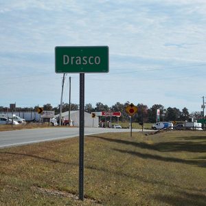 Drasco
 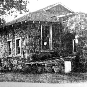 Drasco School
 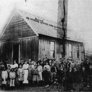 Drasco School; 1925
 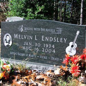 Melvin Endsley Gravestone
 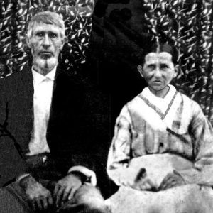 James Elison Foust and Harriet Knight Foust
501-918-3025
calsfoundation@cals.org
calsfoundation@cals.org
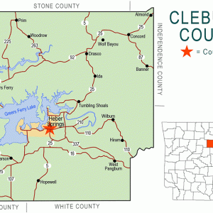
Originally called Crossroads or Cross Roads (because the Batesville-Clinton and Richwoods-Searcy roads intersected there), Drasco of Cleburne County lies about eleven miles northeast of Greers Ferry Lake and includes the lakeside community of Tannenbaum. Still located at a crossroads—at the junction of Highway 25 (Heber Springs Road) and Highway 92 (Greers Ferry Road)—Drasco lies in a strategic spot for the tourism business, serving travelers to the county seat of Heber Springs (Cleburne County) and to the resort areas of Greers Ferry (Cleburne County) and Prim (Cleburne County).
The Osage once hunted in the area. According to local historian Ollie Latch, a branch of the Blackfoot Indians known as Drascos occupied the area in 1793, though the Blackfoot actually occupied parts of the northern United States and Canada. The Old Cherokee Boundary Line goes through Drasco, running diagonally from Wolf Bayou (Cleburne County) across Greers Ferry Lake.
Crossroads was sparsely populated by a few hunters and trappers by 1818. A trading post was established to cater to their needs. Only gradually did the region increase in population. The Little Red River runs between Drasco and Heber Springs. During the early days of settlement in Crossroads, crossing the river was difficult, so many rarely traveled outside the community. At first, the focal point of area settlement was Wolf Bayou, three miles to the north-northeast, but the focus slowly changed over time to Crossroads/Drasco.
In April 1859, the month their seventh child was born near Dalton, Georgia, John Ross and Hannah Caroline Lane Ross set out in an ox-drawn wagon for the hills of Arkansas, settling in the Wolf Bayou/Crossroads area. Four more children were born to the couple in Arkansas. Ross purchased wooded land and cleared it for farming, using his team of oxen to carry away the timber and to plow. He traded in Batesville (Independence County), about seventeen miles away. Local historian Louie Clark called John Ross the founder of Wolf Bayou and Drasco. James Elison Foust moved his family to the area from Mississippi in the early 1850s, dammed Big Creek, and built a grist mill. When water was low, Foust used a team of oxen as a power source for the grinding.
A significant skirmish took place during the Civil War at Crossroads as the Union army was ridding the county of Rebels and irregulars while taking control of Batesville. A notorious bushwhacker called Smith terrorized the Little Red River region, pillaging and looting in the wooded hills of Crossroads and Wolf Bayou. Captain Albert B. Kauffman of the Eleventh Missouri Cavalry Volunteers left Batesville on March 24, 1864, with a detachment of 200 men and six officers to scout the area for Smith and his men. They camped along Raccoon Creek and, after resting, discovered that Smith was just ahead of them. Kauffman and his forces surprised Smith and his men, estimated to number about twenty five, at Crossroads, where the fighting took place. Smith was routed and lost most of his guerrilla band. Two were taken prisoner, found guilty by a military commission, and hanged. The March 27, 1864, Skirmish at Cross-Roads destroyed Smith’s grip on the territory.
An influx of farmers settled the Crossroads area beginning in the 1850s, with the population growing following the Civil War. The raising of livestock became important. The main crops grown in the rocky hill soil were corn, cotton, wheat, and a small amount of tobacco; a few farmers made moonshine from their corn crops and built illegal stills in the rocky hills around Crossroads and Wolf Bayou. Many worked in timber. Sawmills and stave mills were located in the area. The Bruner and Sons Handle Factory in Heber Springs was the main market for the hickory of Crossroads. The Seymore brothers were well known in Crossroads for their logging activities by 1908.
By the early 1900s, several country stores were located in the area, operated by Noah Cannon and the Wards, Spinks, Powells, Fiches, and Nortons. Early churches of the Crossroads area were the Oak Grove and Macedonia Methodist churches. In 1950, the General Baptists built a church in Drasco, which is still active in the twenty-first century.
On May 31, 1917, Mertie Elizabeth Norton of Peter Creek, daughter of a Confederate veteran from North Carolina, was appointed the first postmaster of the new Drasco Post Office, and Crossroads officially became Drasco. The name Drasco was chosen by the Norton family in remembrance of the Drasco Indians. By this time, Wolf Bayou had begun a decline in population.
During World War II, an army air force base for training pilots was built in Newport (Jackson County), and planes occasionally filled the sky in the Drasco area. In the spring of 1943 near Drasco at the Martin Creason farm, air cadet Thomas Arensen of Oak Park, Illinois, who was a trainee at the Newport Army Air Field, crashed his plane in the Creason meadow. The Creason family rushed to the wreckage but could not save the life of the nineteen-year-old pilot.
The lakeside resort of Tannenbaum, developed by the Dwyer Construction and Tannenbaum Rental Agency, has a Drasco address and is considered part of the community, even though, like Drasco, it is unincorporated. Planning for the construction of Tannenbaum began in 1965, and land was purchased in 1967. Tannenbaum has chalet-style homes on the northeastern side of Greers Ferry Lake, as well as a boat dock, a boat ramp, a golf course, and an airfield. A popular restaurant sits atop a bluff overlooking the lake.
Drasco’s first school, which may have been the Comfort School, was built in 1876. A rural school for grades 1–8 existed in 1915; this merged with Concord (Cleburne County) around 1936. The nearby resort town of Greers Ferry was established and incorporated in 1968. With the establishment of the West Side School District at Greers Ferry around this time, elementary and secondary educational services for Drasco students were relocated to West Side.
Prolific country-and-western performer and songwriter Melvin Endsley was Drasco’s most notable resident. In 1956, Endsley wrote one of the most recorded songs of the twentieth century, “Singing the Blues,” made popular by Marty Robbins, Guy Mitchell, and Johnny Steele. In 1970, he left the Nashville, Tennessee, music scene and returned to Drasco. In 1998, he was inducted into the Arkansas Entertainers Hall of Fame. He died in 2004 and is buried at Sipes Cemetery at Drasco.
Drasco’s location at the intersection of two main highways has encouraged growth. About all that is left of nearby Wolf Bayou is the name, whereas Drasco remains a growing community in the twenty-first century. Several businesses are located in town, including two gas stations and a store.
For additional information:
Barger, Carl J. Cleburne County and Its People. 2 Vols. Bloomington, IN: AuthorHouse, 2008.
Berry, Evalena. Time and the River: A Centennial History of Cleburne County. Little Rock: Rose Publishing Company, 1982.
Clark, Louie. Picture History of Healing Springs Township, Cleburne County, Arkansas. N.p.: 1988.
Clark, Louie, and Jeannie Clark McGary. Wolf Bayou and Healing Springs Township. N.p.: 1987.
Fletcher, Erlee. “Ida and Drasco Communities.” Cleburne County Historical Journal 27 (Winter 2001): 122–124.
Latch, Ollie. “The Drasco Community.” Cleburne County Historical Journal 10 (Summer 1984): 45–46.
Stuart, Charles. “World War II Plane Crash near Drasco.” Cleburne County Historical Journal 27 (Fall 2001): 108–110.
Kenneth Rorie
Van Buren, Arkansas


Comments
No comments on this entry yet.