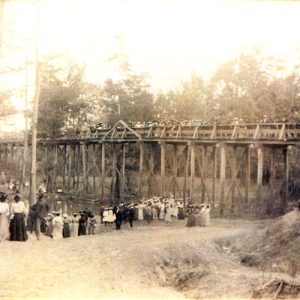
 Baptism Service
 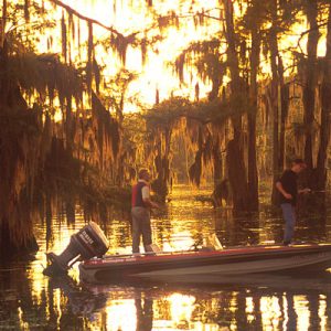 Bayou Bartholomew
 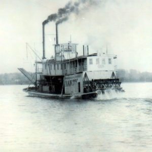 Handy Steamboat
 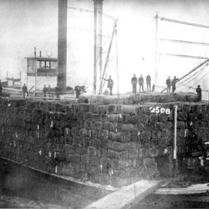 John Howard Steamboat
 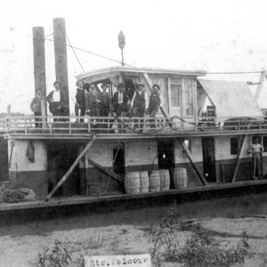 Welcome Steamboat
501-918-3025
calsfoundation@cals.org
calsfoundation@cals.org
Located in southeast Arkansas, Bayou Bartholomew was, until the construction of railroad lines in the area in 1890, the most important stream for transportation in the interior Delta. While the Arkansas and Mississippi rivers served their adjoining areas, it was the bayou that provided a transportation route into an otherwise landlocked area. This route allowed the development of one of the richest timber and agricultural tracts in the Delta. Bayou Bartholomew has the distinction of being the longest bayou in the United States, beginning its meandering 359 miles in Jefferson County and passing through Lincoln, Desha, Drew, Chicot, and Ashley counties before proceeding into Morehouse Parish, Louisiana, where it eventually empties into the Ouachita River near Sterlington.
The present bayou bed was formed by the waters of the Arkansas River during a period when it was constantly changing courses. Approximately 1,800 to 2,200 years ago, the river diverted from the present area of the bayou, and the leisurely bayou began to develop in the old river bed. The first inhabitants along the bayou were Native Americans, who left artifacts along the banks from its source to its mouth.
French explorers crossed the bayou in 1687. Henri Joutel, a member of the ill-fated La Salle expedition, left Texas that year in search, once again, of the Mississippi River. Among the six men he chose to go with him was “Little Bartholomew, the Parisian.” His party crossed the Saline River and the bayou and eventually found Arkansas Post (Arkansas County), where young Bartholomew stayed. It is likely that the bayou was named after this young Parisian. Spanish colonists also took note of the bayou. Don Juan Filhiol, commandant of the District of Ouachita in the 1780s, was impressed with its navigation potential as well as the good agricultural land around it. The colonists used the bayou for transportation as there were no good roads in the area. They used flat-bottom barges, propelled by poling, rowing, cordelling (towing with ropes) or by sails if the wind was favorable.
The advent of the steamboat made the bayou a major thoroughfare for exporting cotton, timber, and other goods, as well as for importing supplies. These boats were on the bayou in Morehouse Parish before 1833. All such commerce halted when the Civil War began but resumed soon after it was over. With the advent of railroads in 1890, steamboat activity began a slow decline, though it continued in Ashley County until some point between 1906 and 1912. Major ports along the bayou in Morehouse Parish were at Point Pleasant and Lind Grove (near Bonita). In southeast Arkansas, the major ports were at Poplar Bluff (present-day Parkdale in Ashley County), Portland (Ashley County), Thebes (Ashley County), Boydell (Ashley County), and Baxter (Drew County). All steamboating was a treacherous business, but according to Ben Lucien Burman, who boated on both large rivers and bayous, “bayou steamboating was steamboating at its worst.” The bayou was much more narrow and shallow than the rivers, and pilots had to avoid sharp bends, shoals, snags, and overhanging trees.
Although steamboat trade was put on hold during the Civil War, the bayou remained, for the duration of the war, a significant transportation route for steamboats carrying troops and supplies. In 1865, Federal cavalrymen under the leadership of Colonel Embury D. Osband carried out a raid to impede this supply route. They reached the bayou in Chicot County and continued down it to Portland and Parkdale, where they captured the Confederate steamer Jim Barkman, which was loaded with corn. After using the Barkman at Point Pleasant in Morehouse Parish to transport their own troops across the bayou, they burned the boat.
After the war, cotton was the primary export shipped through the bayou until the railroad prompted the development of an extensive timber industry, backed primarily by Northern capitalists. Although locals had used the bayou for log rafting since the 1830s, shipment by rail was much more expedient. The timber companies devastated the fine timber stands and then moved out. Farmers followed by clearing the cut-over timber land for farms, which today remain the dominant enterprise along the bayou.
Other than providing a transportation route, the bayou served as the major recreational site for the local people. They swam and fished in it, held barbecues and picnics by it, and were baptized in it. Morehouse Parish communities associated with the bayou are Point Pleasant, Bastrop, Bonita, Jones, Zachary, and McGinty. In Ashley County bayou towns are Wilmot, Parkdale, Portland, and Boydell. Dermott in Chicot County has a long association with the bayou. Places along the bayou in Drew County are Jerome, Baxter, Tillar, and Winchester. McGehee, Pickens, and Dumas are close to the bayou in Desha County. Situated near the bayou in Lincoln County are Tyro, Yorktown, and Tarry. The bayou passes just south of Pine Bluff (Jefferson County).
Once a pristine stream (people drank from it), it is now polluted, log-jammed, and over-sedimented. In 1995, Curtis Merrell of Monticello (Drew County) organized the Bayou Bartholomew Alliance to “restore and preserve the natural beauty” of the bayou. With help from the Alliance, many government organizations—such as the Arkansas Game and Fish Commission, Arkansas Soil and Water Conservation Commission, Arkansas Department of Environmental Quality, USDA Natural Resources Conservation Service, Environmental Protection Agency, U. S. Fish and Wildlife Service, and Ducks Unlimited—and the public, the bayou may eventually reclaim some of its grandeur. Projects underway include monitoring water quality, planting trees for buffer zones, restoring riparian sites ruined by clear-cutting, trash removal, removing log jams, bank stabilization, building boat ramps, and encouraging no-till farming.
For additional information:
Hammond, Richard. An Abstract of Economic History of Transportation on Ouachita-Black River of Northeast Louisiana. Ph.D. diss., George Peabody College for Teachers, 1945.
DeArmond-Huskey, Rebecca. Bartholomew’s Song: A Bayou History. Bowie, MD: Heritage Books Inc., 2001.
———. Beyond Bartholomew: The Portland Area History. Conway, AR: River Road Press, 1996.
———. Interviews with seventy-three people, 1997–1999. Drew County Historical Museum Archives, Monticello, Arkansas.
Horn, Deborah. “A Shaken Alliance.” Arkansas Democrat-Gazette, July 28, 2019, pp. 1E, 6E.
Saucier, Roger T. Geomorphology and Quaternary Geological History of the Lower Mississippi Valley. Vicksburg, MS: US Army Engineer Waterways Experiment Station, 1994.
Rebecca DeArmond-Huskey
Wilmar, Arkansas


I lived in Gillett, Arkansas, as a child and remember fishing in Bayou Bartholomew when we visited friends of my mom. (They lived near the banks of the bayou in Drew County.) I remember a huge catfish I caught on a cane pole and mosquito bites. Thank you for the historical information. As a retired history teacher, I regret I didn’t know the information then so I could have shared it with my students.