 The Little Rock
 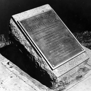 "Little Rock" Plaque
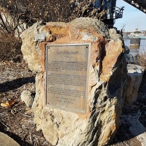
 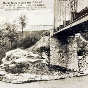 Little Rock [Geological Formation]
501-918-3025
calsfoundation@cals.org
calsfoundation@cals.org
The Little Rock is the rock outcropping on the Arkansas River used as a navigation point during the early exploration of what would become the state of Arkansas. The town of Little Rock (Pulaski County) was established near this point. Sometimes called the Point of Rocks, it is the first rock on the Arkansas River as one ascends from the Mississippi. This is where the foothills of the Ouachita Mountains first touch the river, creating a natural plateau above the floodplain. The rock is sandstone deposited originally in a deep marine environment 320–300 million years ago, a part of what geologists call the Jackfork Formation.
Jean-Baptiste Bénard de La Harpe, one of the earliest European explorers in the region, observed the changing geology of the water’s edge in 1722. On April 9, he noted “rocks sticking out of the ground,” certainly a reference to, especially, that first rock up the river, but he did not name it. La Harpe saved his exuberance for what he called the French Rock—“le Rocher Français”—the “bluff of mountainous rock” up the bend and north of the river, now labeled Big Rock. The French called the smaller outcropping on the south bank “le Petit Rocher” (the little rock), with the term’s earliest appearance on a map occurring in 1799. In the 1950s, the term “la Petite Roche” achieved some local popularity as a name for the outcropping.
The Arkansas Gazette first described the rock on August 20, 1822: “It projects several feet into the river, forming below it a fine basin for boats, and its top reaches perhaps about midway between low water mark and the summit of the bank of the river. The name Little Rock was given it by the aborigines, or the early white settlers of the country to distinguish it from the Big Rock.” Several early accounts tell of the rock being totally submerged by the Arkansas River at highest stage. In 1818, the United States restricted the Quapaw Indians to a reservation in Arkansas, the western boundary of which—known as the Quapaw line—began at the Point of Rocks and extended due south. Arkansas Post (Arkansas County) became the territorial capital in 1819, but the need for a more centralized and less swampy location resulted in the seat of Arkansas Territory shifting to Little Rock in 1821. In 1824, the Quapaw were removed from central Arkansas, opening the reservation to settlement. The Little Rock saw the town grow up around it. As the city of Little Rock became established, ferries crossed the Arkansas River at the rock, and riverboats docked immediately downstream from it. Over the years that the Arkansas River was the lifeblood of the town, the Little Rock remained an important landmark.
On May 31, 1872, Congress authorized the Little Rock Bridge Company to construct a bridge across the river at the Point of Rocks to be available to all railroads terminating at the river, as well as to wagon traffic. Work began on a “shore pier” at the Point of Rocks in October 1872. “Several tons of rock have been cut away and thrown into the river, so much so as to greatly change the appearance of the rock from the lower side,” according to an account in the October 29 Gazette. Two days later, the paper urged some artist “to take a photograph of the ‘Little Rock,’ from which our city derives its name, before it is destroyed by the ruthless hand of civilization.” Though the rock suffered significant reduction, this bridge was never completed. The first permanent bridge was built a mile upstream by the Baring Cross Bridge Company.
On December 8, 1883, a group of businessmen organized the Little Rock Junction Railway Company to build a bridge connecting the Little Rock and Fort Smith rail line with the Little Rock, Mississippi River and Texas railway. The Arkansas Democrat of December 10, 1883, reported that “while the bridge will pass over the historic ‘Little Rock,’ from which this city takes its name, it will be necessary to remove but a small portion of the point” to make the wall necessary for the function of the swing span. The company did not rely on the congressional sanction of the old Little Rock Bridge Company, so the Corps of Engineers claimed not to have the authority to approve or disapprove of the plans for the Junction Bridge. But Corps officials stated that they would have no objection to construction if a couple of “slight changes” in the plans were made. One change involved raising the bridge 0.551 feet, and the other required additional surgery on the rock, including excavation “entirely through the Point of Rocks” so that the channel opening be clear at, and immediately downstream from, the bridge abutment, the foundation of which was the rock itself.
On February 4, 1884, L. D. McGlashan, the construction engineer, anchored his barge at the Point of Rocks to begin making soundings for the first pier. On December 8, 1884, the Junction Bridge opened for traffic.
In 1932, the rock suffered one more reduction. The Civitan Club proposed marking the Little Rock as a historic site, but it concluded that the many railroad tracks in the area would endanger visiting tourists. It persuaded the Missouri Pacific company to allow a portion of the rock to be removed and transported to a more accessible spot. Thus, a 4,700-pound piece of the rock was detached without damage to the foundation of the Junction Bridge and moved to the grounds of City Hall.
In 1970, the Junction Bridge was rebuilt to bring it into conformity with the needs of the McClellan-Kerr Arkansas River Navigation System. A new pier had to be constructed in the river off the Point of Rocks to support the south lift tower, and the reinforced concrete rest pier at the rock became the support shelf for the southernmost truss section of the bridge. In 2001, the Junction Bridge, no longer used by the railroad, was given to the City of Little Rock as a part of a larger real estate transaction. Following the renovation of the Junction Bridge as a pedestrian walkway, the City of Little Rock removed some of the dirt surrounding what remains of the rock formation and created a plaza which opened in 2010. The plaza, called “La Petite Roche Project,” includes several plaques describing the history of the Point of Rocks.
Visual sources for how the Point of Rocks looked before progress took its toll are rare and ambiguous. Clearest from maps is the extension of the point from the south bank into the river. Less certain is the actual height and massing of the rock. A print from Leslie’s Illustrated Newspaper of September 5, 1868, shows the bluff at the point, but the height of the river is uncertain, and the extent of the rock outcropping remains questionable. What is known is that much of the Point of Rocks at the river was removed and that a bridge abutment rests on the rock, encasing the bluff above it, with the track bed resting on the bluff as it extends south onto the plateau.
For additional information:
Arnold, Morris S. Colonial Arkansas, 1686–1804: A Social and Cultural History. Fayetteville: University of Arkansas Press, 1991.
Hebda, Dwain. “The Big 300! Little Rock’s La Petite Roche Marks Tricentennial with Yearlong Celebration.” Arkansas Democrat-Gazette, March 27, 2022, pp. 1E, 3E. Online at https://www.arkansasonline.com/news/2022/mar/27/the-big-300/ (accessed January 24, 2023).
“Moving the Rock to City Hall.” Pulaski County Historical Review 36 (Winter 1988): 93–95.
Peacock, Leslie Newell. “Big Plan for Little Rock.” Arkansas Times. November 22, 2007, p. 11.
Smith, Ralph A. “Exploration of the Arkansas River by Benard de la Harpe, 1721–1722.” Arkansas Historical Quarterly 10 (Winter 1951): 339–363.
Worthen, William B. “The ‘Little Rock’ and the Junction Bridge—The Curious History of a Landmark.” Pulaski County Historical Review 56 (Spring 2008): 9–18.
William B. Worthen
Historic Arkansas Museum


Comments
No comments on this entry yet.